
Trace a Belton Street Address
Use a street address as the starting point, not as proof of every person who may live there. Cass County assessment data can identify a deed holder and the parcel tied to the location. The parcel then supplies a legal description, such as a lot and block in a subdivision, that lets the same land be matched in the recorder index. That chain is stronger than a name match alone because a street address can be written differently across systems. A voter record or telephone directory can add household-era context, but it should be read as a separate source with its own limits.
- Search the Cass County Assessor real-estate form with house number, street name, and Belton. Record the deed holder, parcel number, situs address, and legal description shown by the result.
- Open the parcel in CAMAvision and compare the selected parcel with the nearby street pattern. Keep the parcel number and legal description with the search notes.
- Search the Cass County Recorder iCounty index for the present holder as grantee. Match the legal description, subdivision, instrument number, and recording date before treating a deed as the same property.
- Use voter information only as a limited confirmation channel. Missouri's online lookup is a self-verification form, not a public street-browse tool, while the Cass County Election Authority handles requests subject to state limits.
- For an older address trail, check the Belton telephone directories held on microfiche. A subscriber line can place a name and address in a particular directory year, but it does not establish ownership or list every household member.
The order matters: address, owner, deed, voter evidence, then historical directory evidence. If a deed search reaches its web cutoff, the next channels are the Recorder counter, the Cass County Historical Society, and deed-index microfilm at the genealogy library. That handoff is especially useful when an address has changed form or an old instrument is not imaged online.
Note: A matching street address is a lead, while the legal description is the safer identifier for a specific Cass County parcel.
Search Belton Street Directory Parcels
The Cass County Assessor real-estate search is the practical first stop for a Belton address. Its form accepts partial information and combines entered fields as AND criteria. Use house number and street name together, then add Belton in the city field to narrow a common street. A deed-holder search is useful when a name is already known. The form also accepts parcel number, DBA, legal description, and lot area, and it offers an all-parcels or photos-only choice. No ZIP filter was exposed on the inspected form.
| Assessor field | Input | Required | Belton street-search use |
|---|---|---|---|
| Parcel number | Text | Optional | Use the exact identifier copied from a prior result. |
| Doing Business As | Text | Optional | Search a business or property name when relevant. |
| Deed holder | Text | Optional | Find a named owner or holder before matching a parcel. |
| House number | Text or number | Optional | Pair it with street name for an address search. |
| Street name | Text | Optional | Use with house number; suffix handling was not stated. |
| City | Text or dropdown | Optional | Use Belton as the locality limiter. |
| Legal description | Text | Optional | Search lot, block, subdivision, or other legal text. |
| Lot area | Numeric or text | Optional | Apply the available area range when useful. |
| Parcel-photo filter | Radio control | Optional | Choose all parcels or only parcels with photos. |
The Assessor search screen shown here is the address-entry point for the Belton street directory.
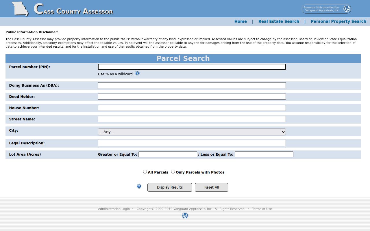
A result can support a parcel search, but the inspected research did not capture a live Belton parcel card. Treat field names beyond the documented search form as unconfirmed until they appear in the selected result.
Browse Belton Streets in CAMAvision
Cass County CAMAvision adds the map side of a Belton street search. The public landing screen exposes Search, Layers, Results, Print, Legend, Tools, and Login controls, plus links for Pictometry, Google Maps, and Street View. Start by locating or selecting the target parcel, then use the results panel and nearby polygons to check whether the selected shape follows the expected part of the street. The map can link the spatial view back to assessment information. It does not turn a map pin into proof of residency.
The CAMAvision map interface is shown with its visible search, results, layer, and tool controls.
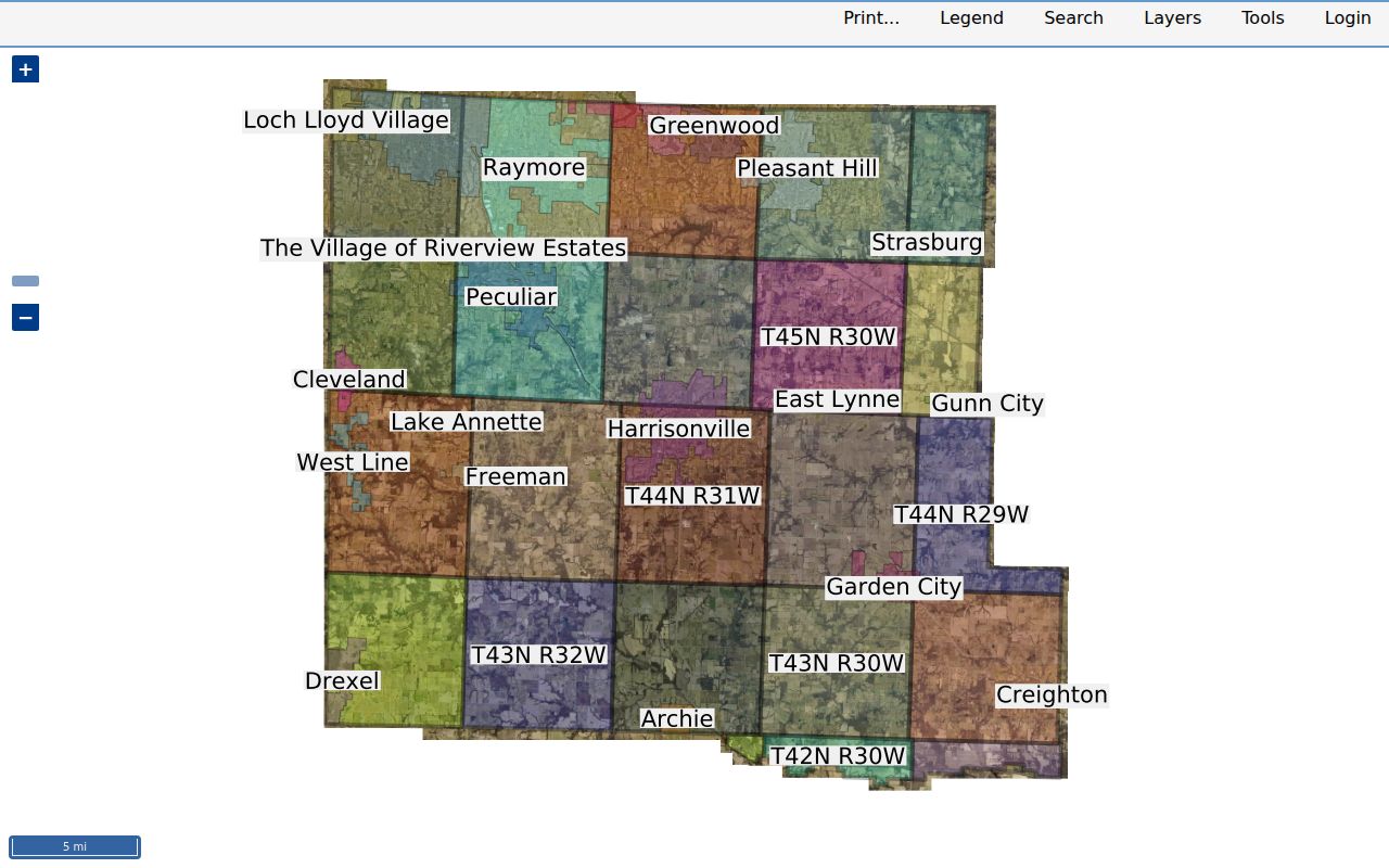
The inspected landing screen does not publish its full inner search-field list or every available layer. For that reason, use a live parcel selection to test a particular map function instead of assuming that a zoning, flood, school, ward, or utility layer is present.
Belton also publishes city, street, subdivision, ward, precinct, zoning, tax-incentive, school, sewer, and snow-route maps through its city mapping page. Those maps help establish geography. The parcel number and legal description remain the bridge to a deed, and the owner name remains a separate question from who may occupy the address.
Belton Street Records by Address
Several record sets can be keyed to the same Belton location, but they answer different questions. The assessor and GIS identify land and assessment context. The recorder explains the ownership trail. City records can date public-facing work or a code record. Voter material is governed by narrower public-field rules, and the historic directory layer is limited to a subscriber or business listing. Keep the source label beside each fact so a mailing address, parcel boundary, and residential address are not blended together.
| Address record | Custodian | Street-level evidence | Access route |
|---|---|---|---|
| Real-estate assessment | Cass Assessor | Deed holder, situs and mailing address, parcel, legal description, values, exemptions, building clues | Web search or office |
| GIS parcel map | Cass GIS / CAMAvision | Parcel polygon, nearby parcels, assessment link, map context | Public web map |
| Deed and index | Cass Recorder | Grantor/grantee, recording date, instrument, legal description, image path | Online from 1980; office from 1940; older Historical Society or microfilm |
| Plat or subdivision | Recorder, assessor, or city GIS | Lot, block, subdivision, street layout, original development | Recorder, GIS, library, or archives |
| Tax material | Collector, Treasurer, or Historical Society | Payment, delinquency, tax account, historical taxpayer clues | Current portal or counter; historic material at CCHS |
| Permit or project | Belton Community Development | Address, record status, project, inspection, and date where public | Public eTRAKiT search |
| Voter record | Cass Clerk / Missouri Secretary of State | Permitted name, address, year, precinct, district, party fields | Self lookup or request under statutory rules |
| Reverse directory | Midwest Genealogy Center / Cass library | Historic subscriber, occupant, or business by address | Belton fiche in library |
Property ownership is not the same thing as occupancy. A parcel card may show a deed holder and a tax-mailing contact, while the situs address identifies the land or building. A permit may connect a contractor or applicant with an address, not a resident. These distinctions keep a street directory useful without making claims that the record does not support.
Turn Belton Parcels Into Deeds
The Cass County Recorder of Deeds makes the Belton street directory's ownership trail more precise. Search the current holder as a grantee, then compare the deed's legal description with the assessor result. A legal description can identify a lot and block, a subdivision, or a metes-and-bounds description. It is the title key. Do not rely only on the street address because deed indexing may use party names, an instrument number, and legal text rather than the common address.
- Parcel
- An assessment identifier for a piece of land, copied from the assessor or GIS result.
- Situs address
- The physical land or building location used by assessment, mapping, and permit records.
- Plat
- A recorded map that translates a subdivision into lots, blocks, streets, and related legal descriptions.
- Criss-cross directory
- An address-first directory arrangement that can associate a historic address with a subscriber, occupant, or business.
The Cass County iCounty Recorder search provides the online entry to the recorded-instrument index.
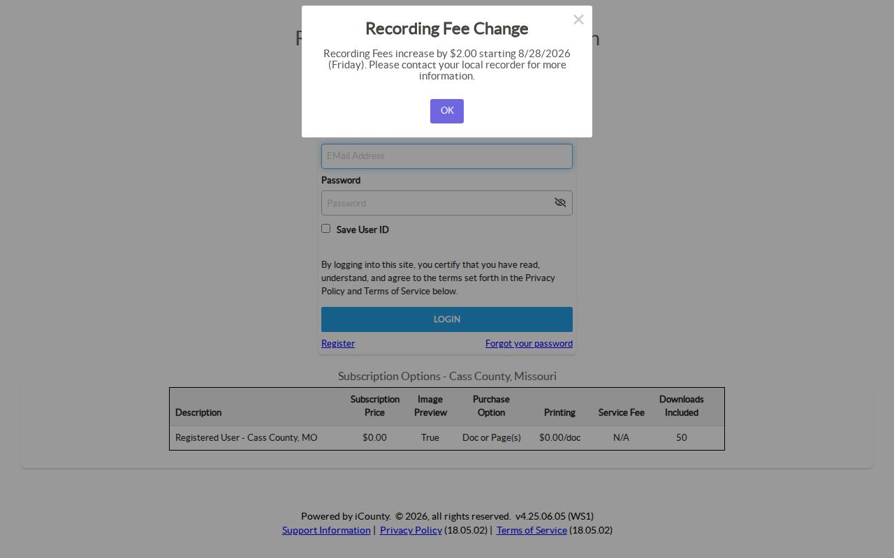
Registered access is free and includes image preview, document and page printing, no service fee per document, and up to 50 downloads. Online real-estate records cover 1980 to the present. The library guide places 1940 to the present at the Recorder office and records dated 1940 or earlier at the Cass County Historical Society, subject to the record-series cutoff.
To move backward, read the purchase deed for the prior grantor, then search that person as grantee and confirm the same legal description at each step. The Recorder's page says the office indexes scans and microfilm and can make certified copies of recorded instruments. It does not prepare documents for recording. For a missing online image, use the counter, Historical Society, or library microfilm route instead of assuming the chain ends.
Note: A trust, estate, or business may be the indexed party, so an owner-name search can require more than one form of the name.
Read Belton Street Permit Records
Belton's Permits, Inspections & Reports route points public users to eTRAKiT for permits, planning projects, licenses, inspections, and violations. Public users can search information without an account; an account is needed for submissions, scheduling, and dashboard functions. The city moved these permit, license, and planning processes to eTRAKiT on October 28, 2024. A record can help date an addition, deck, electrical work, mechanical work, demolition, or inspection, but it is corroborating evidence rather than proof of title or present occupancy.
| Visible eTRAKiT item | What an address search may reveal |
|---|---|
| Record number and type | Identifies a permit, project, license, or related public record. |
| Record status | Shows the status displayed in the public result. |
| Address | Connects the public record to the project location. |
| Inspection and date | Supplies the inspection category and timing where visible. |
| Violation search | Offers an address-keyed route, though record visibility can vary by status. |
The official inspection guide shows fields labeled REC NO, REC TYPE, REC STATUS, ADDRESS, INSPECTION, and DATE. It also identifies public search choices for permits, planning, contractors, licenses, and violations. Monthly reports can supply project dates and types. Do not treat a contractor shown with a record as a resident of the street.
Check Belton Street Voter Boundaries
Voter records may confirm a limited set of registration facts, but they do not create a public Belton street directory. The Missouri Voter Information Lookup requires exact registered first name, last name, date of birth, last four Social Security number, and county. It is meant for a person to check a registration. It has no public street-wide browse mode. For a record request, contact the Cass County Clerk and Election Authority, which maintains the voter database and historical voter lists at the Historic Courthouse.
RSMo §115.157 permits public electronic media or printouts to include a voter ID, name components, street number and direction, street name and suffix, apartment number, city, state, ZIP, township, ward, precinct, legislative districts, congressional district, and party affiliation. The statute's public descriptions also include year of birth and voter history under its separate rules. Full birth dates, Social Security numbers, driver-license numbers, signatures, identity documents, and ballot selections are not public. A voter record does not prove that every person at an address is registered or physically present on the day searched.
Cass County voter lists are documented back to 1903 at the Historic Courthouse. Request a date-specific record in writing, specify the fields and medium needed, and ask about any applicable fee. The research did not locate a Cass bulk-file request form or delivery specification, so those details should be confirmed with the election authority.
Belton Streets Follow Rail Lines
Belton's address geography has a local wrinkle. The city began with an 80-acre purchase in 1869, was platted in 1871, and incorporated in 1872. Its downtown was deliberately rotated to match railroad lines. That history makes a simple north-south grid assumption unreliable when comparing a modern street location with an older plat, map, or deed description. Use the city street and subdivision maps together with the recorded legal description when the route through an older street name is unclear.
Current street-renaming policy requires review by Public Works, Planning, IT/GIS, Fire, and Police. A renamed portion must begin and end at major cross streets, and duplicate or similar names are barred within Belton and its extraterritorial jurisdiction. The sources did not locate a specific historic renumbering or renaming year. That gap is a reason to compare plats and the legal description instead of guessing that an old address maps directly onto the current street name.
Note: The 64012 delivery area and Belton city limits do not always match, so a mailing city alone cannot settle a parcel's jurisdiction.
Find Belton Street Directory Fiche
The historic address layer is strongest in the confirmed Belton telephone-directory microform at the Midwest Genealogy Center. Fiche 40032 holds Belton yellow pages for 1988, 1989, and 1990; white and yellow pages for Belton-Grandview-Raymore from 1991 through 1994; both sections for 1995 and 1996; and both sections for 2001. The markers matter: these are telephone books, not proof of a complete Polk-style city-directory series. A white-page listing normally identifies a subscriber, while a yellow-page entry may identify a business.
Staff assistance is useful because phonefiche can be uncatalogued or stored apart from printed city directories. The Missouri microform holdings list is the documented source for the Belton run. Search the exact address in adjacent available years, record the spelling and subscriber, then compare a changed entry with a deed or obituary date. The Belton city directory collections provide the wider historical-shelf context without replacing this address-first task.
For a local fallback, the Mary B.B. Crouch Genealogy Library holds county deeds and deed indexes on microfilm, newspapers, cemetery volumes, obituary indexes, and family files. Its staff can route a concise question or copy request, although they do not conduct a full research project for a patron. Newspaper and obituary evidence can explain a subscriber change, a move, or a death, but should not be stretched into a household roster.
Respect Belton Street Directory Limits
A Belton street directory cannot disclose every person connected with a house. People whose names do not appear on title, along with other occupants, may not appear on a parcel card or historic subscriber listing. Children, unlisted telephone users, utility customers, delivery information, and DMV address data are not public resident lists. Missouri Safe at Home participants may use a designated substitute address in government records. A tax mailing address can belong to an owner, entity, or agent somewhere other than the property itself.
Lawful use. Belton street and address records are for personal, lawful research and civic or family-history questions. Do not use any record to stalk, harass, intimidate, or harm a person.
Public records change and can be incomplete. Confirm a key fact with the office that keeps the original record, especially when a deed, parcel, mailing address, voter field, or permit record will be relied upon. The official sources identify records and their access routes, not a universal roster of every resident on a street.